February 2026.
Tampa Bay, Florida.
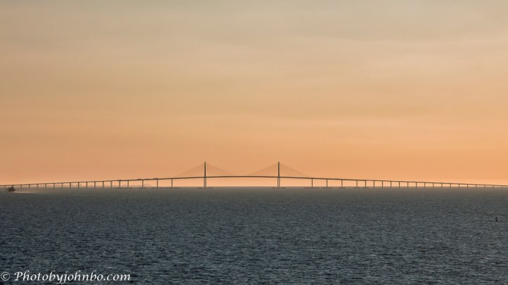
Earlier this year, Lynn and I departed from the Tampa Cruise Terminal on the Norwegian Star. It was a chance conversation with another cruiser that clued me in to the opportunity to photograph another iconic bridge. About 90 minutes after sail‑away, the Bob Graham Sunshine Skyway Bridge appeared on the horizon—just a faint silhouette at first, but the cables and towers quickly sharpened as we drew closer. Before long, I joined a small crowd high on deck 14 at the forward rail, everyone with a cellphone or camera ready as the ship lined up for its approach under the span.
Regular readers know that I feature iconic bridges whenever we encounter them in our travels. I’m always drawn to the engineering behind these structures, and the Sunshine Skyway is no exception. Its cable‑stayed design, twin 430 ft (131 m) towers, and 181 ft (55 m) of clearance make it both visually striking and functionally impressive—especially when you’re sailing directly beneath it.
The bridge we see today is actually the second to span this part of Tampa Bay. The original cantilever structure, opened in 1954, was partially destroyed in 1980 when the bulk carrier Summit Venture struck a support pier during a sudden squall, causing a section of the roadway to collapse and claiming 35 lives. The replacement bridge opened in 1987 with a safer, more modern cable‑stayed design and massive concrete bumpers protecting its piers to make sure a ship strike could never happen again.

Leaving Tampa Bay is a slow, steady process, more like easing out of a driveway than charging into open water. Once the ship backs away from the terminal, it settles into the marked channel and follows the long curve past the port facilities and industrial shoreline. The first time I spotted the bridge, it was off to our left. The next time I looked, it had drifted over to our right. It didn’t take long to notice the channel markers and realize we were almost zigzagging our way toward the span. The route winds south toward the bay’s mouth, eventually carrying us under the Sunshine Skyway Bridge before the Gulf finally opens ahead. It’s not fast, but it’s a surprisingly interesting ride if you’re watching the details.
About the photo: I captured this view of the bridge from just below the ship’s bridge, where the captain and harbor pilot were navigating the channel. I used the Expert RAW camera app, choosing the Samsung S25 Ultra’s Super Telephoto lens to capture the scene. It was nearing dusk as we approached, and the scene was already picking up the first hints of golden hour. In Adobe Lightroom Classic, after selecting the Adaptive Profile and cropping the image to a 16×9 frame to emphasize the towers’ height, I lowered the exposure slightly to bring out more of that warm, late‑day color. I sent the file to Luminar Neo for a final touch with the Enhance AI tool, which helped pull detail from the lightly overcast sky. Click the image to view the metadata and the photograph in 2K HD.
About the map: The Sunshine Skyway Bridge connects the southern end of St. Petersburg with Manatee County, carrying traffic across the mouth of Tampa Bay, where the bay meets the Gulf of Mexico. I wanted to show why it took almost two hours to navigate the bay, so I pulled up Google Maps and marked the cruise terminal. Then I asked Copilot AI to turn the map into something a little more “touristy,” which it did—sort of. It drew roadways straight across the bay for both bridges and placed a very handsome illustration of the Sunshine Skyway neatly on land beside the highway. After two rounds of trying to convince Copilot’s graphic tool to put the bridge over the water, I handed the job to Gemini AI to see what Nano Banana could do. Both AI tools politely declined to understand the assignment, and that’s when I realized I’d fallen into a full‑blown Photoshop rabbit hole. I spent far too much time manually “moving” the bridge into place and fixing the roadway, with Copilot talking me through layers and masks while I muttered at my screen. And because no rabbit hole is complete without an unexpected detour, I even popped into Microsoft Paint at the end to add an arrow pointing to the stretch of roadway that crosses the bay from St. Petersburg to Tampa.
I invite fellow bloggers to join in by creating their own Cellpic Sunday posts. There’s no set theme. The first rule: your photo must be captured with a cell phone, iPad, or other mobile device. The second rule: link your challenge response to this post or drop a comment here with your link so others can find it. And remember, despite the name, there’s no penalty for sharing on a day other than Sunday.
John Steiner.


[…] John’s Cellpic Sunday – 19 July […]
[…] Cellpic Sunday […]
What a gorgeous photo. Such a delicate looking bridge – from a distance, I suppose.
Here is my Sunday cellpic: https://picturesimperfectblog.com/2026/07/19/nun-or-queen/
I had closer images of the structure, but none of them could show the full expanse of the bridge.
Nice backdrop for the bridge! My entry here:
Thanks, PR!
The iconic footprint of the bridge hugs the horizon beautifully, John. And the soft light of that almost the golden hour hue adds a magical touch.
Thank you for the great information, too.
Thanks, Suzette! We left at the right time to get that golden hour color.
Timing is so important. That’s awesome.
[…] John’s Cellpic Sunday […]
Wonderful John. The line of the horizon and the bridge rising up to show the wire supports so clearly against a lovely coloured sky.
Here’s my Cellpic. A bit different
Thanks, Brian!
Great shot, as always! The AI rabbit hole made me chuckle.
On another rabbit hole chase this morning after my laptop bios update. I now have a ticket with advanced support as my password manager no longer accepts my biometrics, and I followed their reinstall instructions before getting escalated. I’m about 90 minutes behind schedule, only the 2nd full day of our return home.
I really like the simplicity of this shot John 🙂 The distant bridge looks very elegant against that soft sky.
On the subject of AI and maps, yesterday I spent ages trying to persuade first Chat GPT and then CoPilot to create a map of our itinerary in North Korea for a presentation I’m giving in a few weeks’ time. ChatGPT flatly refused (in fairness it was quite a complicated itinerary) while CoPilot left out some sections, put the capital in the south east rather than the south west where it should be, and worse, put one major city in the middle of the sea, at least 100 miles offshore!
Thanks, Sarah. I had closer shots, but i was attracted to this minimalist view emphasizing the size and distance.
Also, your version of the struggles with AI mapping mirrored my much simpler need.
[…] Cellpic Sunday […]
[…] Today on a rainy Sunday I am sharing some interior photos from a recent trip to a restaurant that has been in Helsinki since 1930´s for John’s Cellpic Sunday […]
Dear John
The picture of the bridge at dusk is great 👍 👍
Thank you
The Fab Four of Cley
🙂 🙂 🙂 🙂
Thanks!
Stunning photograph! We’ve crossed that bridge a few times but we didn’t know its history, nor its name, so thank you! pp
Glad to be of assistance, Pam! Thanks.
More like a professor! 🙂
[…] week, I’m linking to Bird of the Week, Johnbo’s CellPic Sunday (everything but Phoebe images), welcoming back Lens-Artists: Adventure led by Anne-Christine this […]
That must have been a thrill to be up on the deck to watch the bridge get closer, John! I like that map, too! Here is mine this week:
https://secondwindleisure.com/2026/07/19/sunday-stills-animal-of-the-month-old-macdonald-had-a-zoo/
Thanks, Terri!
Beautiful bit of photography, capturing the bridge at sunset.
Thanks, Anne!
John, Great capture of the bridge. I remember when that bridge got hit and collapsed. Before the span was repaired we drove across the other one. We could see the remaining part of the damaged span.
Thanks, Beth! I’d love to drive across that bridge.
[…] Johnbo’s Cellpic Sunday, here are a few pictures taken of the Godzilla Diorama Museum setup at Silver Age Comic Con on […]
Sailing right under a cable-stayed span at dusk must be a stunning vantage point — I love that a chance conversation with another cruiser tipped you off in time to get up to deck 14 with your camera ready. And your saga of trying to talk three different AIs into moving the bridge over the water, then finally doing it by hand in Photoshop, had me laughing. Our kids are exactly the same about big bridges; a slow channel crossing that zigzags toward the towers would keep them glued to the rail.
Sometimes Artificial Intelligence is just that; artificial. >grin<
[…] John’s Cell Pic Sunday-2026.07.26 […]