April 2025.
Kaua‘i, Hawai‘i.
Last year, Lynn and I visited Kaua‘i, and for a short time, we had guests—our daughter, son-in-law, and grandson. Of course, we showed them some of the areas we’ve discovered on our trips to the island. One of our favorite drives is on the western edge of Kaua‘i, where the road climbs a high ridge offering views into two distinct worlds: first, the lush, green depths of the Makaweli Valley to the east, and then the staggering red depths of Waimea Canyon to the west. Most visitors refer to the latter as the Grand Canyon of the Pacific, and from the first overlooks, it’s easy to see why. But the canyon is only the beginning of what this road reveals. As the drive climbs into Kōkeʻe State Park, the red cliffs give way to forested ridges and cooler air, and the landscape slowly tilts toward the island’s wilder edge. Higher still, the viewpoints open not onto the canyon at all, but toward the vast sweep of the Nāpali Coast—the sheer green walls of Kalalau Valley and the distant shimmer of the Pacific. It’s a transition from carved rock to coastal wilderness, all in the span of a few winding miles.

As the road winds upward, the scenery shifts from lush green valleys to canyon walls. One unmarked roadside stop offered a view of ridges folding into one another and, far below, a solitary farm beside the Makaweli River. Its fields form a patchwork amid the surrounding greens, a quiet sign of human hands at work. The valley is part of the Makaweli watershed, where rain from the highlands gathers into a narrow ribbon of water that threads through the forest before opening into these small pockets of cultivation. From above, the whole scene—half wilderness, half working landscape—is visible only to those who happen to pause at just the right bend in the road.

The Waimea Canyon Lookout is the first major stop along the drive, and it’s easy to see why it draws a crowd. It’s a view I’ve taken in on every trip I’ve made to Kaua‘i. This photo was taken from a broad viewing platform that extends toward the rim, giving visitors a sweeping view into the heart of the canyon—layered cliffs of red and green, ridges carved into sharp angles, and valleys that seem to fold endlessly into the distance. From this vantage point, the scale becomes unmistakable; the canyon feels both immense and intricate, a landscape shaped by time and water. It’s no wonder the canyon has earned the nickname “Grand Canyon of the Pacific.”

At this stop, we encountered a Kanaka Maoli (Native Hawaiian) giving a talk on the history of his people and the island. We arrived midway through his demonstration, so we missed part of it, but what we heard was fascinating. He shared stories of Kaua‘i’s indigenous culture, tools, and traditions. At the conclusion, he noted that he’s not a park employee and added, with a smile, “Feel free to tip.”

This wasn’t a named viewpoint, but the crowd made it clear that something was worth seeing. Like everyone else, we climbed over the highway guard rail and followed a dirt path toward the cliff’s edge. The short trail split in both directions, offering different angles on the valley below—lush, rugged, and wide open to the sky. It was one of those unofficial stops that feels like a shared secret, passed from traveler to traveler.

Just past the final canyon overlooks, the landscape undergoes a transformation. While the pavement remains Highway 550, the scenery shifts as Waimea Canyon Drive merges into Kōkeʻe Road. The red dust of the canyon gives way to the deep greens of the high forest. In a wide clearing, a cluster of rustic buildings appears, flanked by a broad parking area. We found a spot at the far end and started toward the museum, but the aroma from the lodge restaurant at the other end of the lot quickly changed our plans—it was just past noon, after all.

Kōkeʻe Lodge sits in a small clearing at the heart of the park, a rustic stop that feels like a unique mountain retreat. Inside, guests warm up by the stone fireplace while the restaurant serves hearty, no‑nonsense comfort food—perfect after a morning on the road. The lodge also manages a handful of nearby cabins for those who want to linger in the forest overnight, far from cell service and closer to the stars.

It was lunchtime, and the place was busy, with a line of guests waiting to order at the counter. We finally placed our order and found a seat by the fireplace. The higher altitude brought cooler temperatures despite the sunshine streaming in through the windows. One culinary note: we ordered a sandwich with smashed potatoes on the side, having never seen them on a menu before. The dish consisted of baked baby red potatoes, flattened and deep‑fried—a culinary treat, certainly not “health food.” For us, it was simply a welcome pause: a good meal, a bit of music, and a chance to settle into the slower rhythm of the uplands before continuing our tour.

We enjoyed our musical lunch, browsed the gift shop, and headed toward our car, stopping at the Kōkeʻe Museum on the way. The interpretive center features displays and placards that describe Hawaiian history, native species, and the geology of the upland region. The striking birds in this diorama are ʻIʻiwi, famous for their bright vermilion plumage, once used to create the feathered capes and helmets of Hawaiian royalty. Finding them in the wild today takes a bit of a hike—and a lot of luck. The diorama was carefully arranged to evoke the upland habitat just outside, with layered foliage and a painted backdrop of ridges and sky.

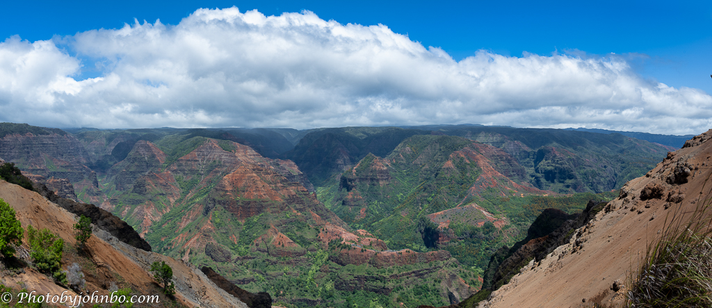
At Kalalau Lookout, the view shifts from the deep reds of Waimea Canyon and the forest green uplands to the rocky coastline of northwest Kaua‘i. The Nāpali Coast isn’t easily reached, but when the weather cooperates, the coastline is nothing short of magnificent. On this day, though, the clouds moved in and out with a mind of their own, revealing only brief hints of the valley below. The ridges appeared and disappeared in slow motion, as if the landscape were breathing under a shifting veil. It wasn’t the sweeping view we’d hoped for, but something was compelling in the mystery—the sense that the valley was present, immense, and simply choosing not to reveal itself all at once.

As the clouds shifted, I took the opportunity to capture a wider, panoramic glimpse of the valley’s layered cliffs and deep green folds. The broader view helps convey the scale of the place, with the ridges cascading toward the now‑invisible coastline. As it turned out, this would be our last stop on the drive. One more viewpoint lies about a mile beyond Kalalau Lookout at the very end of the road. However, the highway was closed, and reaching Puʻu O Kila would have required a hike likely to bring more clouds.

In 2013, we stopped at Puʻu O Kila Lookout. The road was open—and so was the panorama. From this higher vantage point, the Nāpali Coast unfolded in full view—jagged cliffs draped in green, plunging toward the Pacific in a series of dramatic folds. The ocean stretched beyond the valley, framed by scattered clouds and the afternoon sunlight. It was one of those rare moments when the land, sea, and sky seemed to agree on clarity—and the coastline revealed itself without hesitation.

We first spotted the Red Dirt Waterfall on our way up the road—no surprise, really, since it sits just beyond the guard rails, partially obscured by a sea of parked cars. On the way down, we found a spot to pull over and stepped onto the short trail tucked just inside the roadside barrier. The waterfall isn’t large, but it’s striking: a narrow stream carving through vivid red clay, its path shaped by years of erosion and seasonal runoff. The iron‑rich soil gives the landscape its bold color, a reminder that even small flows can sculpt dramatic terrain over time.

Coming back from our journey on Waimea Canyon Drive, the view of the Pacific Ocean demanded my attention, and I pulled off the highway to capture the moment. From this final overlook, the land fell away in layers—forested slopes and farmland meeting the coastline. It was a quiet pause before we headed back into the town of Waimea. After a day of ridges, waterfalls, and shifting mist, the ocean offered a steady horizon—vast, blue, and waiting.
About the photos: The images were captured with either my Samsung S23 Ultra or my Nikon Z7 II paired with a Nikkor 28–400 f/4–8 VR lens. I applied Adobe Lightroom Classic’s Adaptive Profile to the RAW files and sent everything to Luminar Neo for final processing. Lightroom’s AI tools helped remove a few distractions along the way. For this journey, I shot far more images than I featured here—you can find the full gallery on my Flickr album here. A future Travel Tuesday post will turn to the Kōkeʻe Museum, where I’ll explore the history of the islands through a few of its exhibits.
P.S. If you’d like to see Waimea Canyon from above, I’ve shared photos and reflections from a powered‑glider flight I took over the canyon—an unforgettable experience made possible by a local flight instructor, Gerry Charlebois. You can find that post here.
John Steiner

What scenery John
Indeed! Waimea Canyon feels like stepping into an older, quieter Hawaii where the landscape is more like the “old Hawaii” that people first discovered.
No wonder that’s a favourite drive – the views are stunning!
A truly natural wonder, and they keep it that way!
John, I am loving your posts from Hawaii. Your images and descriptions are great. This one took me back to the day we drove through Waimea Canyon. It was cloudy and overcast the day we went so our views were much different than yours. Even with the clouds the views were spectacular.
Is there ever a bad travel day in Hawaii? >grin<
Thanks, Beth.
So beautiful John! Loved your narrative.
Thanks, Anne!
You always do such a great job narrating your journeys, John and with wonderful photos. Thanks for always sharing.
Thanks, Donna! I do enjoy telling as well as showing the stories. 🙂