
Coeur d’Alene, Idaho.
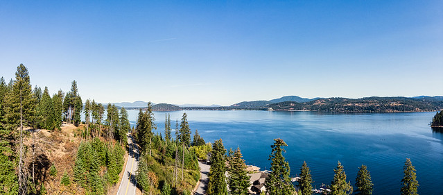
If you find yourself traveling on I-90 through Idaho, you’ll pass through the city of Coeur d’Alene. Just east of the city is Idaho State Highway 97. The scenic drive follows along the eastern shore of the lake about 36 miles (58 km) to the town of Harrison and ends at Idaho State Highway 3. The road is two-lane and has few passing lanes, so expect a leisurely drive and allow at least 90 minutes one-way. The opening photo is a view captured from my drone. In fact, all of the photos in this post were captured from my Mavic Air launched from scenic pull-offs along the roadway.

Our trip down the byway was longer than 90-minutes as it was a detour from I-90. When we arrived at Harrison, we turned around and headed back toward I-90. If you arrive at Harrison around the lunch hour, you will surely find one of the restaurants lining the highway to your taste. If you are headed toward the Palouse, this byway ends at Idaho 3, where it meets the White Pine Scenic Byway and its southern route to the Palouse area of Washington State and Idaho.
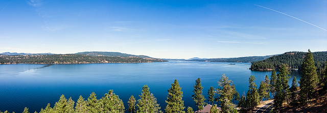
You’ll notice that I captured lots of panoramas from the drone for this post. Truth is that from the highway level, there are few viewpoints that really show off the lake itself. Many of the scenic pull-offs were vistas when they were created. Over time, the tall evergreens grew up to hide the views of the lake.
While that may seem like a disadvantage, you’ll find enough lake views to satisfy most tourists. You’ll want to spend time on the Mineral Ridge Trail at Beauty Bay, the Thompson Lake Wildlife Refuge, or the Trail of the Coeur d’Alenes if you have time.

The highway is open throughout the year, indeed we saw lots of local traffic using the highway as well as the ever-present out-of-state license plates. Keep an eye out for eagles between Wolf Lodge Bay and Beauty Bay, in December and January. If you are on a summer trip, though, you’ll be far more likely to see Idaho’s well-known osprey. They have a wingspan reaching to six feet (2 m) and hover over the lake looking for their meals, the kokanee salmon, large and smallmouth bass, and trout.

The size of the lake lends itself to creating large panoramic images, so you’ll find no shortage of them in this post. The lake is approximately 25 miles (40 km) by 10 miles (16 km) and is a natural lake fed by the Coeur d’Alene River and the St. Joe River. The lake’s outflow is the Spokane River that flows westerly until it joins the Columbia River.
All of the images above (and some extra images) can be found in my Flickr album featuring the dronie shots I captured on our scenic drive. Click on any of the images to go to the gallery to see all of them. Instead of using the drone’s ability to create panoramic images automatically, I prefer to take multiple images and stitch them together in Adobe Lightroom.
John Steiner

This really shows the advantage of having a drone. Thanks for the result. Coeur d’Alene, Palouse, the French-speaking origins of the first pioneers is stilll reflected in the cartography.
We see a lot of adaptation as far east as the Dakotas, but we also have a lot of Scandinavian names in North Dakota and Minnesota.
On our trip last year to Washington, we missed traveling through the Palouse. I am hoping to add that to our trip plans for this fall.
Your drone images are beautiful. I wish I had taken the detour when I drove on I90 a few years back.
Idaho is a beautiful state… but then again, aren’t they all? 🙂
That looks like my sort of drive, and you’ve done a fantastic job on those panoramas!
Thank you! Though the drone has a “panorama” mode where it automatically rotates, captures, then stitches the separate images, the result is a jpg image. There is so much more flexibility when I keep the drone in RAW mode and let Lightroom do the stitching. From there, I can crop the panoramic view as I wish, or even make super panoramas of three or more images.
Great work! Such a beautiful spot!
It is hard to take a bad photo of such a beautiful place. 😀
These images are incredibly beautiful, John. Thank you for taking us there. 🙂
Thank you. The place photographs well!!
A detour this scenic is certainly no inconvenience!
That is so true!
Wowww
Thank you for the road trip tour, John! We’ve visited Couer d’Alene several times now that we live an hour away but we haven’t yet made that Eastern side of the lake drive. Where we live now is right on the Spokane River which is dammed in two spots making it Long Lake or Lake Spokane in our area. Your drone caught some amazing shots!
Thanks. Ii know you will enjoy that amazing scenery.