October 2025.
Val Verde County, Texas.
Scattered across the vast Texas highway systems, these roadside picnic areas offer more than a break from the wheel—they’re shaded respites where travelers can stretch their legs, maybe share a meal, and soak in slices of scenery. Most, however, don’t include restrooms but do provide a few tables under a mesquite canopy. Others are surprised by sweeping views, historical markers, or glimpses of wildlife. But few match the drama of the TxDOT Picnic Area overlooking the Pecos River High Bridge, where the tables sit perched above a canyon carved deep into West Texas rock. It’s not just a place to pause—it’s a definite photo op.

From the overlook, the land unfolds in layers—rocky cliffs, a mighty river, and dramatic skies. The Pecos River Valley stretches southward toward Mexico, carving its way through the rugged terrain of Val Verde County. This river was once a lifeline for Native tribes and frontier settlers, known for its deep canyons and dramatic bends. The Pecos has long marked the edge of the familiar—the place where maps faded and the phrase “West of the Pecos” came to symbolize untamed country. Today, it’s a corridor winding through desert plains and box canyons, feeding sparse vegetation and offering rare glimpses of water in an arid land.

Long before the highway bridged the canyon, the railroad carved its own precarious path. In the 1880s, Southern Pacific engineers faced the daunting challenge of crossing the Pecos River canyon. Their solution was the “Loop Line”—an 11-mile descent of steep grades and tight curves, winding through the cliffs with tunnels and ledges still visible today. Trains crept down to a low iron truss bridge near the river’s mouth, where the Pecos meets the Rio Grande. That treacherous route was abandoned in 1892 when the original Pecos High Bridge was completed. The structure was replaced in 1944 with a taller, sturdier bridge that is still in use today. However, the railroad bridge is around the bend upstream and isn’t visible from the picnic area.

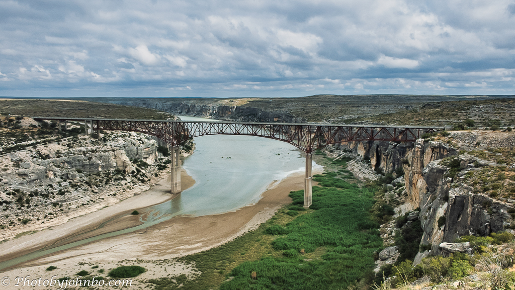
Today, the trains run high and straight, far above the canyon floor—but the land still tells stories. From this vantage point, the Pecos River winds southward through a rugged corridor of cliffs and scrub, eventually merging with the Rio Grande near the U.S.–Mexico border. The view stretches toward that distant confluence, where the river becomes a boundary, and the terrain grows even more remote.

Looking upstream, the Pecos River threads through a rugged corridor of cliffs and scrub, winding its way toward the Amistad Reservoir. The terrain here is stark, with limestone bluffs and scattered mesquite. Though the water appears calm from this height, it’s part of a larger system that eventually feeds into the Rio Grande. The reservoir itself, formed by the Amistad Dam, lies miles to the southeast and serves as a vital water source and recreational hub. But from this vantage point, the river feels ancient and untamed, carving its own path through the desert stone.
The view is dominated by the modern, massive US 90 highway bridge, a steel arch completed in 1957 that soars 273 feet (82 m) above the Pecos River—making it one of the tallest bridges in Texas. This elegant span carries a steady stream of traffic across the remote West Texas canyon. Just upstream, hidden around the bend, is the canyon’s other vital crossing: the 1944 railroad bridge. This heavier, more utilitarian structure, built to replace the historic 1892 viaduct, quietly continues to serve, carrying heavy freight and Amtrak’s Sunset Limited and Texas Eagle on their transcontinental journeys.
From picnic table to canyon rim, this overlook offers more than a roadside pause—it’s a window into Texas’s layered past and enduring scale. The Pecos River carves its way through stone and stories, flanked by tunnels from a bygone railroad era and spanned by bridges that mark human ambition across generations. Whether drawn by the engineering, the geology, or the sheer drama of the view, this spot reminds visitors that even the quietest corners of the highway hold photos worth framing.
About the photos: All photos were captured on my Samsung S25 Ultra using Pro mode, and the DNG files were edited in Adobe Lightroom Classic. AI technology was used in some photos to remove distractions (like a fence in the lower part of the photo of the railroad tunnels). Some images were also tweaked in Luminar Neo.
I invite fellow bloggers to join in by creating their own Cellpic Sunday posts. There’s no set theme. The first rule is that your photo must be captured with a cell phone, iPad, or other mobile device. The second rule is simple: link your challenge response to this post or drop a comment here with your link so others can find it. And remember, despite the name, there’s no penalty for sharing on a day other than Sunday.
John Steiner

[…] q #Cellpic Sunday – 26 April […]
[…] Johns Cellpic Sunday […]
What an amazing place to stop for a rest John. Great photos and information.
Here’s my Cellpic Sunday contribution
Thanks, Brian!
Trees around our village – Ladyleemanila
Stunning rest stop and gobsmacked views John. I love your descriptions and the related history of the Pecos region. Thank you..
Thanks, Suzette! It is a photogenic place!
Beautiful photos, that bridge is incredible!
Thanks, Pam! It is incredible!
So much history there! My entry, also historical, by chance 😉:
Beautifull picture
Thanks!
John, a picnic area with amazing views!