National Weather Service Bulletin
Fargo, ND — Issued April 4, 2026
A powerful spring storm delivered 9.6 inches of snow to Fargo on Saturday, setting a new single‑day snowfall record for April 4. The previous record of 4.7 inches, set in 2023, was more than doubled by this event. Forecasters noted the storm carried unusually high moisture, producing heavy, wet snow across southeast North Dakota.

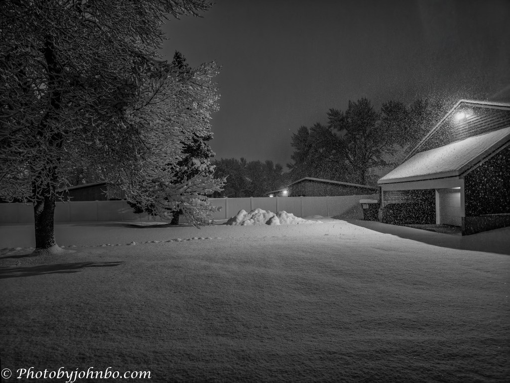
In the opening photo, taken at 6:32 AM, the only movement was the steady fall of flakes drifting through the garage lights, as if spring itself had stopped mid‑stride. About forty minutes later, when I stepped back into the backyard, the storm’s official numbers already made sense. The heavy, wet snow clung to every branch and rooftop, muting the neighborhood into a kind of suspended quiet. Shortly after sunrise, the world looked even softer, the weight of the record snowfall settling into every corner of the yard.
Just a week earlier, we were wrapping up our time in Tucson after a stretch of heat that felt more like early summer than spring. March had already delivered four days over 100°F (37.8°C)—an unusually early burst of desert heat in a month that typically sees none. Leaving that warmth behind in late March, we expected a gentle transition into spring back home. Instead, Fargo greeted us with a record snowfall that brought the season to a sudden, unmistakable pause.
In the days since, the snow has already begun to settle and melt, but that morning pause still lingers in my mind. Spring will find its footing again soon enough, but for a few hours, the season reminded us that North Dakota still has a few surprises left.
About the photos: When I awoke early Saturday morning, I was ready to work on photo processing from our Tucson trip. While I brewed my coffee, I opened the shades and noticed that the forecast high winds hadn’t materialized; instead, a gentle but heavy snowfall was settling in. I could have grabbed the Nikon, but using my Samsung S25 Ultra felt right for a Cellpic Sunday dedicated to this record‑breaking storm. With the Expert RAW app, I captured several DNG files from the patio. The stark whites against the buildings and trees immediately suggested black‑and‑white. After basic tweaks in Adobe Lightroom Classic, I sent the files to Silver Efex for conversion, chose a preset that fit the mood, and returned them to Lightroom for final adjustments to contrast and clarity. I’ve posted 2K HD versions of the images in my Flickr gallery here.
I invite fellow bloggers to join in by creating their own Cellpic Sunday posts. There’s no set theme—the only rule is that your photo must be captured with a cell phone, iPad, or other mobile device. The second rule is simple: link your challenge response to this post or drop a comment here with your link so others can find it. And remember, despite the name, there’s no penalty for sharing on a day other than Sunday.
John Steiner

[…] Cellpic Sunday […]
We have saying: “April, April – does what he will” – I remember in 2023 we also had lots of snow at the beginning of April. How long did the snow last in your case (ours was mostly gone within a day or two). I adore that snow covered tree. Fresh snow is so pretty! — Completely different: https://picturesimperfectblog.com/2026/04/12/you-must-be-joking/
Funny that I have no memory of the one in 2023 Elke..I have to look up my whatsapp archive if I told someone about it 😂.
It was about 10 cm, maybe more, in the Odenwald. I don’t think we got any in the Bergstraße. But I’ve got snow wrapped sheep from that day. It was in 2022 (sorry, typo) and a belated April joke, i.e. on the second.
That snowfall was on April 3-4, with a combined total of 13 inches. It was still covering some of the lawn yesterday, but by evening a gentle rainfall started. This morning, only the piles of snow left by the snow removal company remained.
Those piles can last a long time. But 13 inches! Wow. We never get that much here, even in the middle of winter.
That’s why we head south for much of the winter. >grin<
👍🏽😄
Omg! I have once seen some flakes flying around in April here, but that is a lot of snow..Shovels out! Looks so serene though..
My entry here:
I’m glad to say that our condo association hires a company that keeps the snow at bay and another handles our summer lawn care. Snow is pretty when it’s falling, but by the next day, it’s often a muddy mess. >grin<
Indeed!
[…] John’s Cellpic Sunday […]
Wonderful snowy scenes John. The light is great on both.
My cellpic is also cold
Thanks, Brian!
Thanks, Brian! I don’t suppose you get to see much snow.
Wow, it looks like the beginning of winter, not April in Fargo, John! We had snow here last week, but not to those levels! It must be quite a shock to return from summer-like conditions into that winter postcard, John.
Beautiful, magical photos, John. I love the light source from the snow itself and that of the outdoor lighting.
Thank you for your processing techniques; as always, I learned new insights from your wisdom.
Stay warm and safe.I hope you do not have much shoveling to contend with.
Thanks, Suzette! We live in a condo building, and all yard care and snow removal is courtesy of our Condo fees. >grin<
Crazy weather but the photos are great. 😊
Thanks, Pepper!!