July 2023.
Jekyll Island, Georgia
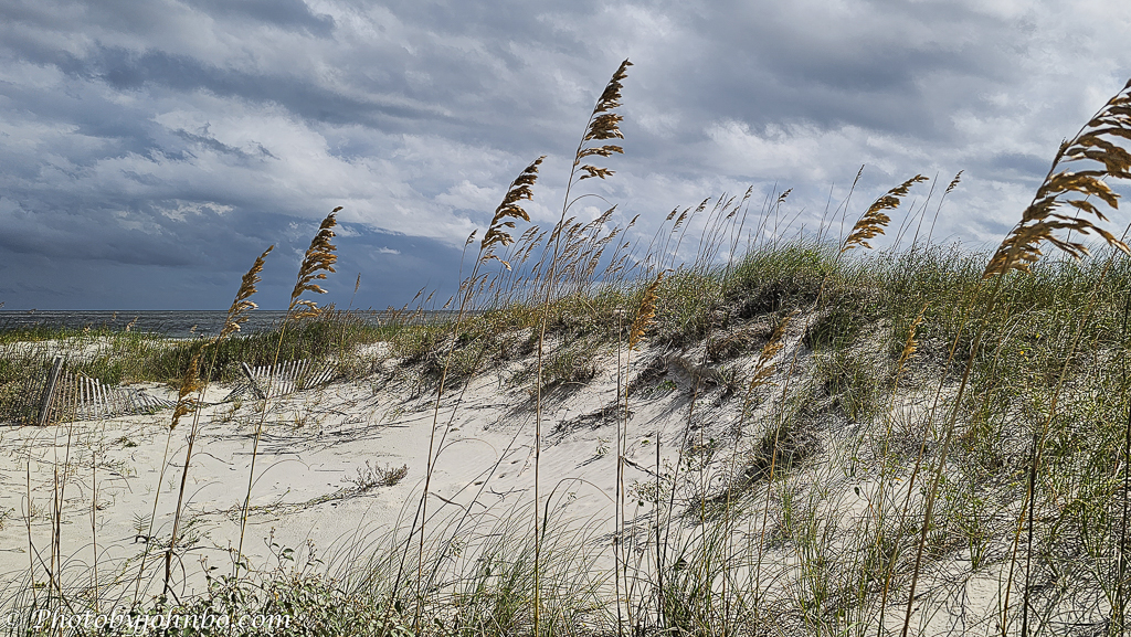
There’s a quiet kind of wonder to Jekyll Island. Our first visit unfolded gently, photo by photo, as we explored the island. Standing near the dunes as wind rustled through the sea oats and storm clouds gathered overhead, as usual, I found myself drawn to the ocean. The sweeping sand dunes and tidal wetlands define this stretch of Georgia’s coast. On a blustery and hot Georgia afternoon in July, sea oats bent in the warm and gusty breeze.
There are four barrier islands near Brunswick, Georgia: Jekyll Island, St. Simons Island, Little St. Simons Island, and Sea Island. Jekyll Island is the southernmost of these and plays a central role in the region’s identity. The group of islands collectively known as the Golden Isles is known for its serene beaches and protected natural habitats. Jekyll embodies the Golden Isles’ blend of coastal beauty, Southern charm, and ecological preservation.

As we stepped out of the car in the beach parking area, a cyclist passed the Great Dunes Beach Deck on Jekyll Island. The Great Dunes Beach Deck on Jekyll Island serves as both a scenic boardwalk and an homage to the island’s resort history. Situated in the heart of Great Dunes Park, it welcomes visitors with shaded seating, ADA accessibility, and coastal views, once home to the Great Dunes Golf Course. Today, it is a passage to the Atlantic Ocean, a public access area, and a social gathering place documenting Jekyll Island’s shift from exclusivity to shared experience.

The dunes at Jekyll Island form a natural barrier between the Atlantic Ocean and the island’s interior. From the deck, we could barely see the beach and the ocean beyond. These sandy ridges help prevent erosion, protect habitats, and support nesting sites for shorebirds and sea turtles. Shaped by wind and tides, the dunes are stabilized by native vegetation like sea oats and grasses, which anchor the sand and preserve the island’s ecological balance. On the right, a boardwalk beckoned us to journey to the beach.

The boardwalk gave way to woven matting as Jekyll Island’s beach access meets thoughtful design. The blue mobility mat stretches across the sand, granting strollers, wheelchairs, and bikes equal passage to the shore without disturbing the fragile dunes. But just ahead, a red warning sign stands as a sober counterpoint to the ease of entry. It warns beachgoers about fast-changing tides and submerged sandbars that can mask drops of up to 10 feet.

Despite the summer conditions, the beach was sparsely populated, with only a handful of swimmers cooling their feet in the wet sand. Conditions were far from calm, and the scene reflected a day shaped more by weather than recreation.

Google tells me that the marshland in this photo is a classic example of a coastal salt marsh; it’s part of Jekyll Island’s expansive estuarine system. These wetlands form in low-lying areas near the ocean, where saltwater mixes with freshwater from nearby rivers or creeks. The landscape features dense stands of smooth cordgrass, which dominate the marsh zones, along with pockets of standing water and mudflats exposed at low tide. These elements create a dynamic environment crucial for nutrient cycling and shoreline stabilization.

Salt marshes like this one play a vital role in the local ecosystem. They act as natural buffers against storm surges and flooding, absorb carbon from the atmosphere, and support a wide range of wildlife—from fiddler crabs and periwinkle snails to migrating shorebirds and juvenile fish. The mosaic of vegetation and open water provides ideal breeding grounds and shelter, while also serving as a filtration system that helps maintain water quality.

The Jekyll Island Causeway is the sole vehicular access point to and from Jekyll Island. It connects the island to U.S. Highway 17, just south of the Sidney Lanier Bridge, and serves as the gateway for all cars entering the island. While pedestrians and cyclists can also use the causeway without paying a fee, all vehicles must pass through the entry gate and pay a parking fee to access the island. There are no other roads or bridges leading to Jekyll Island, making the causeway its only land-based connection. From a stop along the causeway, I photographed the Sidney Lanier Bridge. You can find a more complete description of the bridge in my Cellpic Sunday post here.
About the photos: All images for this post were captured on my Samsung S23U. Most images were processed in Luminar Neo with assistance from Adobe Lightroom Classic. There were no AI modifications for the photos in this post. For those who like to pixel-peep or view the metadata, you can find my Flickr gallery here.
John Steiner

A wonderful place to explore John
It was, indeed!!
How very beautiful! We have 2 American friends living here who come from Georgia originally and I can see why they love our coastline so much, John. It has barrier islands and many similarities xx
I’ve been to the North Carolina barrier islands, but the ones I visited were far more populated. 🙂
Beautiful collection John, really like all the water images!
Thanks, Pamela! I really enjoyed my time looking for subjects to shoot.
We have stayed on Little St. Simons Island numerous times — it is a special place. Great photos!
It is, indeed! Thanks!!
John, thank you for this great post about Jekyll Island. This would made a wonderful travel brochure for the island. Jekyll is the southernmost barrier island in Georgia that can be reached by road. You have shown the beauty of Georgia’s barrier islands with your beach and salt marsh images. I live farther north on the Georgia coast but the landscapes are very similar to Jekyll.
You’ve showcased such a beautiful coastal landscape here – it makes me want to visit one day!
Put it on your list, and while you are at it, travel further west and visit Padre Island National Seashore at Corpus Christi, Texas!
Thanks for the beautiful images and information John!
Thank you, Anne!
This looks like such a pretty and peaceful place!
We could have spent more time there, it was so beautiful!
Lovely tour John. I have fond memories of Jekyll island from our family visits when I was a young lad.
I never visited any of the eastern coastal islands until after I retired… an opportunity missed in my youth.
Those were my favorite beach trips to Jekyll.
This looks beautiful. Excellent photos.
Thanks, Egidio!