January 2023.
St. Augustine, Florida.
Our winter of 2023 brought us to Florida for the first time—not as cruise ship passengers, but as land-based explorers. On a friend’s recommendation, we booked a stay at Spanish Trace Ocean Club, a beachfront condo complex on Anastasia Island. The property sits on a short connector between the Atlantic shoreline and the Jimmy Buffett Memorial Highway, which quickly revealed one of the area’s more unusual features. Walk with us as we explore Ocean Trace Road, where the pavement gives way to sand and signage marks the start of a coastal highway unlike any other.

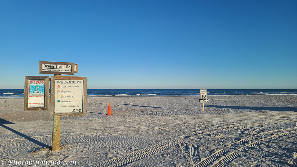
On our early walks around the resort, we discovered a curious transition at the end of Ocean Trace Road. What begins as a conventional street soon dissolves into sand, continuing as part of a regulated coastal highway. This stretch of beach in St. Augustine, Florida, is more than a scenic shoreline; it’s a civic interface where signage, speed limits, and seasonal traffic patterns shape how locals and visitors navigate the edge of land and sea. Leaving the main gate, we begin our walk at the edge of Ocean Trace Road, watching for traffic—there’s no sidewalk here, just pavement that leads directly to the beach.

As we step onto the sand, the rules of the road follow us. A “Speed Limit 10” sign stands firm in the dunes, flanked by orange traffic cones and a “One Way” directive that reminds us this isn’t just a beach — it’s a regulated corridor. Tire tracks stretch ahead, tracing the path of vehicles that navigate this sandy highway under the watchful eye of seasonal signage and shifting tides. The ocean rolls quietly to our left, but here, it’s the infrastructure that speaks first.

From this vantage, the beach stretches south toward Dondanville Road and beyond, part of a larger network of drivable sand in St. Johns County. Though often described as a 12-mile (19 km) beach highway, the route is segmented — broken by soft sand, conservation zones, and seasonal closures. Ocean Trace to Dondanville spans roughly 0.8 miles (1.3 km), one of the more consistent stretches. Other ramps, such as Crescent Beach and Fort Matanzas, offer access to additional segments, but the entire route is anything but continuous. It’s a patchwork of civic planning, environmental adaptation, and local tradition.

Our walk along the beach highway ends where the vehicles settle in, and the signage fades — replaced by beach towels, umbrellas, and the unmistakable scent of sunscreen. We’ve traced the civic edge of Ocean Trace Road, from pavement to sand, cones to coastline. Now it’s time to veer off the traffic lane and join the “people part” of the beach — the one with fewer rules and hopefully no need to check for tire tracks before stretching out.
About the photos: All photos were captured with my Samsung S23 Ultra and minimally processed in Adobe Lightroom Classic. The Spanish Trace image was edited in Photoshop using AI to remove the “No Parking” sign, as Lightroom Classic’s removal tool proved inadequate. The photos are posted in 2K HD on my Flickr site.
I invite fellow bloggers to join in by creating their own Cellpic Sunday posts. There’s no set theme—the only rule is that your photo must be captured with a cell phone, iPad, or other mobile device. The second rule is simple: link your challenge response to this post or drop a comment here with your link so others can find it. And remember, despite the name, there’s no penalty for sharing on a day other than Sunday.
John Steiner

[…] John’s Cellpic Sunday […]
I found it hard to click like on this post John. Driving those heavy vehicles on the beach causes irretrievable environmental damage. The micro organisms necessary for the health of the oceans and eventually us are permanently damaged by compaction under tyres. I could go on.
Maybe this could be of interest of those who care
https://www.sciencedirect.com/science/article/abs/pii/S0272771424004268
Then again, they are good photos of the expanse of sand and sky.
Here’s my contribution. I welcome comments 😁
https://www.sciencedirect.com/science/article/abs/pii/S0272771424004268
Thanks for your perspective, Brian. I had never seen a beach highway like this before. I didn’t think much about it, other than the typical American obsession with the automobile. Are beach highways prevalent in your region?
Cars are banned from all but 2 beaches around here and all the Queensland beaches. No beach highways at all.
Only in remote areas that are unpatrolled, can the 4WD idiots do their crazy stuff.
[…] John’s Cellpic Sunday – 22 March […]
[…] Cellpic Sunday […]
So incredibly … flat. It’s reminds me so much of Saudi Arabia. Yes, definitely does. Here is my cellpic for today: https://picturesimperfectblog.com/2026/03/22/cats-have-talent/
Interesting comparison. I have never been there, but I can believe you, for sure.
On the Persian / Arabic Gulf side, not so much on the Red Sea side.
Beautiful sunrise – Ladyleemanila
A unique highway. It is not easy to discern the lanes. Must have been a challenge to walk there, John. Great photos. And thank you for sharing your processing tips. Much appreciated. Safe travels.
Thanks, Suzette. The “highway” is wide, and there is plenty of room for vehicles to stay in their lane, even though there are only edge markers, no lane markers.
Thanks John. That’s good to know. It looks like a serene landscape/area.
[…] John’s CellPic Sunday-2026.03.22 […]
John, I’ve never been to this Florida beach highway. Thanks for sharing it with us. Daytona Beach is the only one I’ve ever been to that allows driving and parking on the beach like this.
Same for me, Beth. Reading Brian’s comment and his link tells me why these highways aren’t so prevalent.
John, here’s mine https://wanderingdawgs.com/2026/03/22/cellpic-sunday-junkanoo-for-st-patricks-day/
Thanks!
Great photos and very interesting. In all our travels, we’ve never come across a beach highway.
This was my first, so imagine our surprise when we walked the road to the beach and saw the road continue past the usual beach barricades.
😀Is that it??
Wow!
This is incredibly wonderful. I would love to drive here, under the speed limit of course 🙂
It’s certainly a surprising find when you consider so few beaches allow it.
Fun story John. I never understood or liked cars driving on the beach. Florida seems to be one of the few states that allows this.
Indeed, Brad. Reading Brian’s comment and link, I can see it’s probably not a great idea.
[…] Cellpic Sunday March 22, 2026: – Silent Sunday – Sidewalk Scene […]
[…] Shared with John’s Cellpic Sunday […]
Wonderful post and photos, John. No matter how long I’ve lived in the USA, driving on a beach is something that still feels foreign and inappropriate. Maybe it’s because I’m used to lots of people on the beaches in Brazil. No place for cars.
And it is not good for the local ecosystem. I have never seen an organize public highway on a beach.
PS: Here’s my entry:
https://throughbrazilianeyes.com/wild-water-ancient-land-the-rio-grande-along-el-camino-del-rio/
I have heard that Florida is one of the notorious African climate of North America 🇺🇸. I hope 🤞 and think that the photos in this article are used intentionally to express those facts.
Florida definitely has a warm, subtropical climate, and the beach road makes for some interesting photos. I’ve also learned a lot from readers about the environmental side of beach driving—there’s more complexity there than I realized.
[…] John’s CellPic Sunday-2026.03.29 […]
[…] Cellpic Sunday March 29, 2026: – Silent Sunday – Sunday Flowers […]